MONTPELIER, Vt. – The state of Vermont is facing potentially catastrophic flash flooding that hasn’t been seen in the region since Hurricane Irene in 2011, according to the National Weather Service.
This threat comes after deadly and historic flooding was reported in New York‘s lower Hudson Valley on Sunday. At least one person was killed, and numerous water rescues were conducted after torrential rain caused rivers and streams to overflow their banks, leading to roadways being washed away. The NWS issued a Flash Flood Emergency for parts of Orange, Putnam, Rockland and Westchester counties due to the catastrophic flooding.
WHY RARE ‘HIGH RISK’ FLOOD DAYS NEED TO BE TAKEN SERIOUSLY
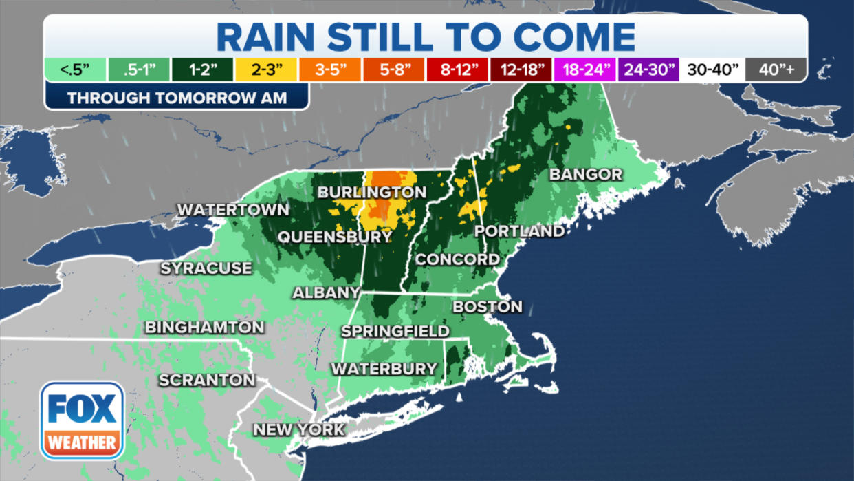
Forecasters say multiple rounds of moderate to heavy rain will soak portions of Vermont in New England, as well as parts of northeastern New York state. Between 2 and 5 inches of rain is expected in those areas through Tuesday morning, with locally higher amounts of up to 7 inches possible.
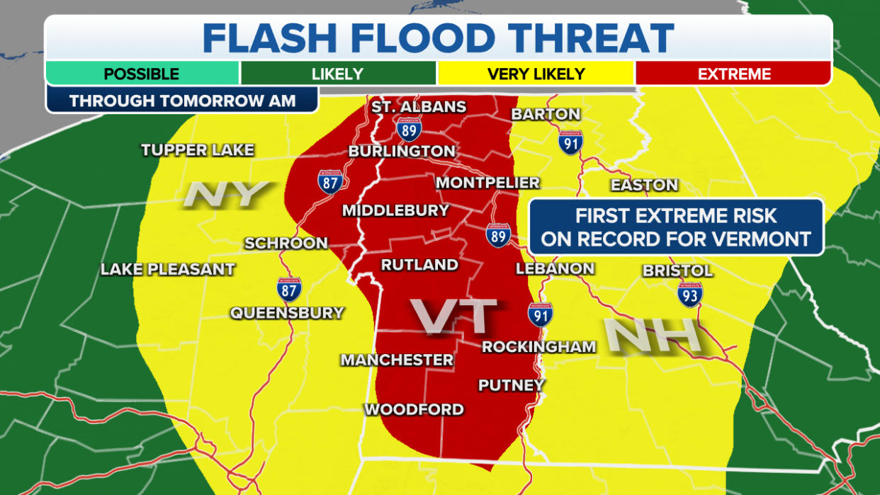
NOAA’s Weather Prediction Center (WPC) has placed most of Vermont and portions of northeastern New York under a rare “high risk” of excessive rainfall – the first high risk issued for Vermont since August 2011 during Hurricane Irene.
When a high risk – the highest risk level that can be issued – is in place, it means severe, widespread flash floods are expected in the highlighted areas.
High risks are only issued on about 4% of days (including tropical and non-tropical events), but this risk category accounts for 39% of flood-related fatalities and 83% of flood-related damages in the continental U.S., according to research by WPC meteorologists.
“Expect significant to potentially catastrophic widespread flash flooding through Monday evening, with possible impacts not seen since (Hurricane) Irene,” the National Weather Service office in Burlington, Vermont, wrote in a forecast discussion.
Irene produced a wide swath of 5 to 8 inches of rain across Vermont, which led to devastating mudslides and deadly flooding.
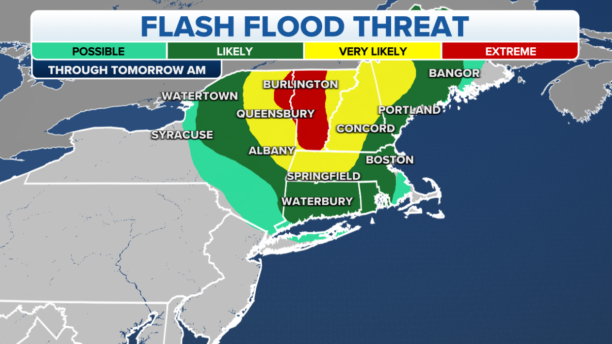
Cities under the WPC’s high risk for flash flooding include St. Albans, Burlington, Montpelier, Middlebury, Rutland, Manchester and Woodford in Vermont. Plattsburgh in New York is also included in the high-risk area through Tuesday morning.
Flood Watches have been issued across New England and in parts of the Northeast through at least Tuesday afternoon.
The Flood Watches stretch from portions of northwestern Maine through New Hampshire, Vermont, western Massachusetts, Rhode Island and Connecticut in New England. Eastern New York state is also included in the Flood Watch.
A Flash Flood Emergency was issued for portions of central Vermont through Monday afternoon, and more Flash Flood Warnings are likely to be issued across the region throughout the day and into Tuesday.
On Monday, nearly the entire state of Vermont was placed under a Flash Flood Warning through at least 2:30 p.m. EDT.
Because of the risk of torrential rainfall, Vermont Gov. Phil Scott has declared a state of emergency.
“The State Emergency Operations Center has been activated, and the Department of Public Safety, Agency of Transportation and other state agencies and departments will be working overnight and throughout Monday and beyond to assist cities and towns in their response,” Scott said in a tweet on Sunday.
The highest rainfall totals will be found across portions of northern New England and northeastern New York through Tuesday morning. In the higher elevations in Vermont, rainfall totals could be between 2 and 5 inches, with locally higher amounts of up to 7 inches possible in some areas.
Emergency officials have urged residents to stay off the roads if possible and to use extreme caution if travel is unavoidable.
Vermont State Police said emergency crews have been conducting water rescues in several communities, and about two dozen roads have been closed across the state.
“Make an evacuation plan before it becomes necessary,” state police said on Twitter. “Do not drive or walk through floodwaters. The water can obscure washouts, carry debris and strong currents, and be deeper than it appears.”